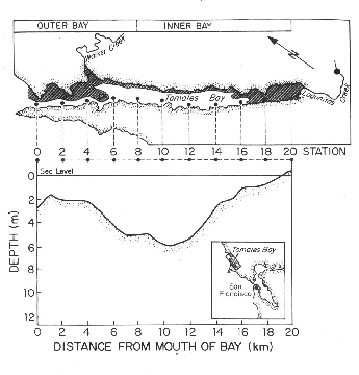
Figure 1. Map of Tomales Bay sampling stations.Most sampling was conducted between stations 0 and 18. Usually, Surface samples only were collected at stations 0, 16, and 18. Other locations were sampled at both the surface and midwater.
The general water sampling procedures and analytical procedures are described in Smith et al. (1987, 1989, 1991). (see reference in LMER/BRIE publications list). For the analytical measurement methods, see references in Smith et al. (1991). Other technical notes are as follows:
COLUMN COMMENTS
1. Surface (bucket) or midwater (Niskin bottle) samples.
2-5. Julian day of year, year, date, time (Pacific Standard) of sample collection.
6. Station, reported as km from mouth of bay. (Figure 1).
7. Particulate carbon (micromol/liter).
8. Particulate nitrogen (micromol/liter).
9. Particulate phosphorus (micromol/liter).
10. Total suspended load (mg dry wt/liter)
