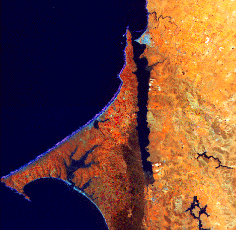
NASA ER-2 false color infrared photograph of Tomales Bay, California, and surrounding watershed. For scale, the bay is approximately 20 km in length and is oriented NW-SE. (NASA photo).
Click on the small pictures to see them at a larger size.
NASA ER-2 false color infrared photograph of Tomales Bay, California, and surrounding watershed.
For scale, the bay is approximately 20 km in length and is oriented NW-SE. (NASA photo).
Click on the small pictures to see them at a larger size.
Central to the research at Tomales are the facilities available. A laboratory with approximately 120 square meters of covered work space and additional storage space has been set up at the Marconi Conference Center, a part of the California State Parks System, on the northwest shore of Tomales Bay. This convenient arrangement allows researchers to use housing and meal accommodations provided by the conference center and ready access to the bay. The laboratory consists of two buildings: one containing a large wet lab/staging area, diving locker, tool room, instrument room, and a computer lab/office. The computer lab has the base station for two weather stations we maintain. Available instrumentation includes computers (getting old by now) salinometer, pH meters, and other instrumentation brought-as needed-from the investigators' home institutions. The second building is an isolated lab for working with hazardous materials. In addition, there is a large deck area and surrounding lawn which can be used for sample processing and out-of doors experimentation. Field and logistical equipment include a 7 meter boat on loan from NOAA, a van, several ctd's and thermographs, two mooring buoys, and several field "dome" incubation chambers.
In addition to the above, the principal investigators and co-investigators have access to well equipped personal laboratories and general facilities at their home institutions.
Several institutional sets of data are also valuable to the project. The U. S. Geological Survey (USGS) maintains three stream gauges in the watershed: two on Lagunitas Creek and one on Walker Creek. We receive those data on a regular basis, and we routinely use two of the stations (along with other data) in calculating an ongoing water budget for the watershed. The Marin Municipal Water District (MMWD) and the North Marin Water District (NMWD) both provide additional data used for the water budgeting. Another important data set is the upwelling index data provided by NOAA's National Marine Fisheries Service, Southwest Fisheries Science Center .

This page was last updated by SVS April 13, 1998.

Maintained by Stephen V. Smith at svsmith@soest.hawaii.edu