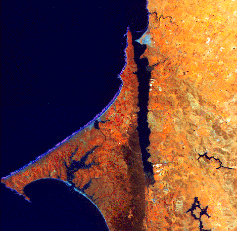
NASA ER-2 false color infrared photograph of Tomales Bay, California, and surrounding watershed. For scale, the bay is approximately 20 km in length and is oriented NW-SE. (NASA photo).
Click on the small pictures to see them at a larger size.
NASA ER-2 false color infrared photograph of Tomales Bay, California, and surrounding watershed.
For scale, the bay is approximately 20 km in length and is oriented NW-SE. (NASA photo).
Click on the small pictures to see them at a larger size.
Tomales Bay (Opening photo and Figure 1) is a straight, long, narrow, shallow (20 km x 1.4 km x 3 m) bay about 50 km north of San Francisco. Much of the watershed lies in Federal
park land, and the bay is part of the Gulf of the Farallones National Marine
Sanctuary. The watershed occupies about 560 square kilometers, 20 times the bay area and half the area of Marin County. Total county population is about 250,000 persons.
The watershed contains approximately 11,000 persons. By contrast with the
human population, there are an estimated 20,000 cattle in the watershed.
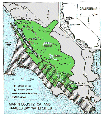 Figure 1. Map of Tomales Bay and its surrounding watershed. The map shows the location of major water catchment reservoirs, stream gauging stations, weather stations, and the "BRIE" research laboratory.
The watershed is rugged. Maximum elevation is the west peak of Mt. Tamalpais
(794 m) at the southeastern extreme of the watershed. Several other peaks in
the watershed exceed 300 m. The bay occupies the seaward (northwestern) end
of a rift valley formed by the intersection of the San Andreas Fault with
the coastline. The area east of the bay consists of Cretaceous Franciscan
greywackes, shales, conglomerates, and serpentinites. Point Reyes
Peninsula, west of the bay, consists of Mesozoic granites. The rift valley
southeast of the bay contains Quaternary alluvium.
About 40% the watershed is covered by clay-loam soils which support grasslands. Much of the grassland consists of introduced annual grasses used for pastures which replaced indigenous perennial grasses. About 20% of the watershed is covered by brush and the remainder woodland. Much of the woodland is forested. This area was harvested for both timber and firewood during the latter part of the 19th century, with some activity continuing into the 1940's. About 80% of the watershed is used for agriculture, primarily the grazing of dairy and beef cattle, while the remaining portion is in federal or local park land.
Stream flow provides the major material linkage between the watershed and bay. Two major stream systems drain into the bay. Walker Creek and its tributaries drain much of the eastern watershed (LC; Figure 2; about a third of the area) and enter the bay near its seaward end. Several streams, dominated by Lagunitas Creek and with the smaller watershed of Olema Creek (LC, OC; Figure 2) also drain part of the eastern watershed as well as the landward portion of the rift valley. These streams drain about half the watershed and enter at the southeastern end of the bay. The remainder of the watershed is drained by local streams along the southwest and northeast shores of the bay. Flow from about 40% the watershed area enters 6 water catchment reservoirs used by the Marin Municipal Water District (Figure 1); that catchment has been well characterized since 1955.
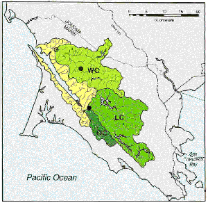 Figure 2. Map showing the locations of Walker Creek (WC), Lagunitas Creek (LC), and Olema Creek (OC) subwatersheds. Small shoreline watersheds are unlabelled. USGS Stream gauging stations at locations of black circles. LC water composition was sampled at the gauging station; WC was sampled at the site of the open circle.
The USGS maintains gauges on Walker and Lagunitas Creeks, downstream of the catchment reservoirs and gauging about 50% of the watershed area. In addition, we sampled stream water composition between 1987 and 1995. Rainfall over the past century has averaged about 90 cm/yr, with considerable interannual and seasonal variation. The climate is "mediterranean;" most rainfall occurs between November and April. About 60% of the rainfall is lost to evapotranspiration, 6% is removed for use outside the watershed, and the remainder flows into the bay. Groundwater flow accounts for less than 1 % of the freshwater in the watershed. Superimposed upon this annual cycle are large, but largely unpredictable, interannual variations in rainfall and runoff. Six years of our investigation have been during a sustained drought, with greatly reduced rainfall and runoff less than half the long-term average. There also appears to be about a 20-year cycle in the amount of annual rainfall; even the recent "severe drought" is no drier than this part of California experienced during the dust bowl years of the 1920s and 1930s. The area experienced record rains during the winter of 1995.
Rapid sedimentation is occurring in Tomales Bay. Comparison of hydrographic charts prepared in 1861 and 1957 and correction of the charts for changing sea level yields a baywide average infilling rate of about 5 mm/yr (Figure 3).This is equivalent to a watershed erosion rate of approximately 80,000 tons/yr. We assume most of that erosion occurred in the decades of intensive agricultural development of the watershed following the arrival of European settlers in the latter part of the 19th century, but the largest sediment influx to the bay seems to have been in the decades between about 1930 and 1960. The present sedimentation rate in the bay, based on both bathymetric changes since 1957 and sediment yield measurements, has been about 1-2 mm/yr.
 Figure 3. Map showing baywide sediment accumulation, based on bathymetric changes between 1861 and 1994. These data were corrected for sea level change.(Figure by J. Rooney).
Tomales Bay is also influenced by water exchange with the coastal ocean.
Coastal seawater composition shows significant variation over an annual
cycle, largely because of varying strength of coastal upwelling. The most
important effect of the upwelling in terms of coastal water composition is
the varying delivery of nutrient-rich water to the photic zone. The most
intensive upwelling occurs during the summer, in response to strong, often
persistent northwesterly winds. Direct inorganic nutrient delivery from
upwelling is not of major direct importance to the bay. Nevertheless, there
may be important indirect effects of coastal upwelling on the nutrient
dynamics of the bay. By stimulating primary production in coastal waters,
the upwelling elevates the concentration of particulate organic matter in
the coastal waters. This particulate organic matter is delivered to the bay
by tides and particle settling.
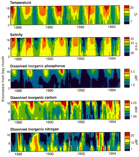 Figure 4. Water composition in Tomales Bay versus distance from the bay mouth. Note the strong seasonal cycle and interannual variations in water composition, especially for the "inner bay," more than 8 km from the bay mouth. (Figure by K. Sender and B.G. Bays, Jr.)
Tomales Bay has four distinctive benthic biotic communities. Salt marshes occur near the mouths of both Walker Creek and Lagunitas Creek, and smaller pocket marshes occur along much of the northeastern shore. The bay also has eelgrass (Zostera marina) beds, especially in the outer third of the bay. Most of the bay floor is covered by mud bottom with an extensive infaunal community, and much of the mud surface has a microalgal community. Despite the extensive benthic plant communities, phytoplankton apparently account for about 70% of the baywide annual gross primary production rate of about 400 g C per square meter. Respiration, by contrast, is about equally split between the plankton and benthic communities.
Of particular interest to the present study, respiration appears to exceed primary production by about 10%. This implies that the net ecosystem metabolism of the bay is supported to a significant extent by the import and oxidation of organic matter produced outside the system. We estimate that about half the organic matter supporting net heterotrophy is supplied from land and about half from the coastal ocean.
Water mixing in the bay, predominantly driven by tidal exchange, is slow. In the summer, water exchange between the bay and ocean exceeds a month; in the winter, with higher freshwater flow, exchange decreases to a few days. The combination of slow water exchange, net evaporation, and high net heterotrophy in the summer results in water composition being strongly modified from the composition of either the freshwater inflow or the coastal ocean. The bay becomes slightly more saline than the adjacent ocean, dissolved inorganic phosphorus builds up in the water column, and dissolved inorganic nitrogen largely disappears. The phosphorus buildup apparently reflects release of phosphorus during the oxidation of organic matter, while the nitrogen disappearance represents the net effect of denitrification. These processes occur during the winter; however, they are slower and more rapidly diluted by water exchange. Consequently, winter water composition largely reflects mixing between runoff and coastal ocean water.
During the winter, high-runoff periods characterized by low salinity, the amounts of dissolved carbon, nitrogen, and phosphorus in the water are largely controlled by the physics of water exchange. That exchange occurs too rapidly for chemical reactions to modify the water composition much. By contrast, the dry season water composition, when water exchange is slow, reflects internal chemical reactions; the bay is effectively a closed "incubation chamber" in which the whole-system chemical reactions may be assessed (Figure 4). Dissolved phosphorus and carbon are released to the water by these internal reactions. Some of the dissolved carbon released in this fashion escapes to the atmosphere, but the dissolved phosphorus simply accumulates in the water column. Dissolved nitrogen is also released by these decomposition reactions, but the nitrogen is subsequently stripped to the limits of analytical detection by the process of denitrification. Interannual variations in these seasonal trends are most conspicuously demonstrated by dry season phosphorus concentrations, because it lacks the alternative loss pathways exhibited by carbon and nitrogen.
The chemical reactions within the system are dominated by the metabolic processes of primary production and respiration. Some of the respiration pathways take on particular interest. The loss of nitrogen to denitrification controls the availability of nitrogen in the water column and causes nitrogen to limit primary production in the system. Some respiratory pathways substantially alter the composition of sediments on the bay floor. For example, sulfate reduction in the sediments reduces the high seawater concentrations of sulfate to zero in sediment interstitial water and results in the deposition of diagenetic sulfide minerals in the sediments. Methanogenesis builds up methane concentrations in the interstitial water to the point that the gaseous methane horizon can be mapped by seismic reflection (Figure 5). Thus, the bay sediments provide a historical record of changing inputs from land over time of at least some aspects of chemical reactions within the system.
![]() Figure 5. High-resolution seismic reflection profile in Tomales Bay. The well-stratified reflecting layer about four meters below the sediment surface represents the bay floor when sea level flooded the valley formed by the San Andreas fault about 5000 years ago. That reflector, which is at approximately the depth of methane saturation, is largely obscured beneath an undulating, seismically opaque horizon that results from bubbles of methane gas in the sediments. The methane is the product of anaerobic decomposition of organic matter in the sediments. (Seismic profile, Gary Mann, U.S. Geological Survey)
Figure 5. High-resolution seismic reflection profile in Tomales Bay. The well-stratified reflecting layer about four meters below the sediment surface represents the bay floor when sea level flooded the valley formed by the San Andreas fault about 5000 years ago. That reflector, which is at approximately the depth of methane saturation, is largely obscured beneath an undulating, seismically opaque horizon that results from bubbles of methane gas in the sediments. The methane is the product of anaerobic decomposition of organic matter in the sediments. (Seismic profile, Gary Mann, U.S. Geological Survey)
Tomales Bay serves as a useful research and training site for the examination of material fluxes to, within, and from a coastal ecosystem (Figure 6). Studies such as this enhance our understanding of human perturbations of the coastal ocean.
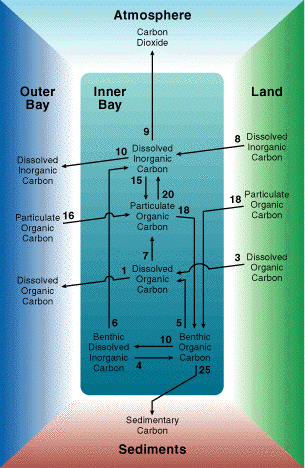 Figure 6. Observations and experiments in the system lead to abstractions in the form of budgets and models of material cycling. This diagram illustrates the cycling of carbon in the system, and similar diagrams can be constructed for nitrogen and phosphorus. Units are in moles of carbon per square meter per year. The budgets as illustrated represent steady state conditions over about the past 20 years. It is also possible to look over longer timespans or to look at annual or shorter term variations. The purpose of such diagrams is to better understand how coastal marine systems are affected by material inputs, and by variations in those inputs. (Diagram by B.G. Bays, Jr)
The information described in this section represents a combination of accumulated historical knowledge about Tomales Bay and research undertaken during this program.

This page was last updated by SVS April 13, 1998.

Maintained by Stephen V. Smith at svsmith@soest.hawaii.edu