THESE DATA ARE PRESENTED COURTESY OF MARIN MUNICIPAL WATER DISTRICT (MMWD)
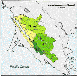
Flow from about 40% of the Tomales Bay watershed area enters 6 water catchment reservoirs used by the Marin Municipal Water District. The water catchment has been well characterized since 1955. The resulting data can be used to calculate water flow into Tomales bay. Soulajule Reservior stores water from the Walker Creek watershed and empties into the Northeastern side of Tomales Bay via Walker Creek, while Nicasio Reservior and Lagunitas-Bon Tempe-Alpine-Kent Lakes (LBAK) trap water from the Lagunitas Creek watershed which eventually empties into the Southern end of Tomales Bay via Lagunitas Creek. Lagunitas-Bon Tempe-Alpine-Kent Lakes are stung together as a complex because they are in series within the watershed itself, with Lake Lagunitas at the highest altitude and Kent lake at the lowest altitude. Therefore outflow from the LBAK complex into Lagunitas Creek is determined solely by Kent Lake outflow. Water volume for each reservior is in units of 1000's m3 , while all other values are in m3.
CLICK ON FIGURE TO SEE WATERSHED MAP WC= Walker Creek Watershed LC= Lagunitas Creek Watershed OC= Olema Creek Watershed
CLICK ON WATER IMPOUNDMENTS OR METEOROLOGIC VARIABLE TO ACCESS THE ASSOCIATED DATA
NICASIO RESERVIOR
The online data columns are in the following format:
LAGUNITAS, BON TEMPE, ALPINE, AND KENT LAKES
This data set combines all four lakes for a single volume. The same is true for spill, release, and production values.The online data columns are in the following format:
PAN EVAPORATION
Pan evaporation is measured at both Soulajule and Nicasio Reserviors and is reported here in mm / month. This data is used by MMWD to calculate evaporation from their reserviors. A regression has also been developed for evaporation at Tomasini Point:
Tomasini Point evaporation (mm/month) = [Soulajule pan evaporation (mm/month)]*0.44 + 5.0
The online data columns are in the following format:
LONG TERM RAINFALL Rainfall has been collected monthly since 1877 at Wells Fargo Bank (formally Crocker Bank) in San Rafael, CA and since 1878 in Lagunitas, CA by MMWD. It is reported in mm and the online data columns follow the following format: